
![peeking-underground-with-giant-flying-antennas-[hackaday]](https://i0.wp.com/upmytech.com/wp-content/uploads/2024/05/185070-peeking-underground-with-giant-flying-antennas-hackaday.jpg?resize=800%2C445&ssl=1)
Peeking Underground With Giant Flying Antennas [Hackaday]

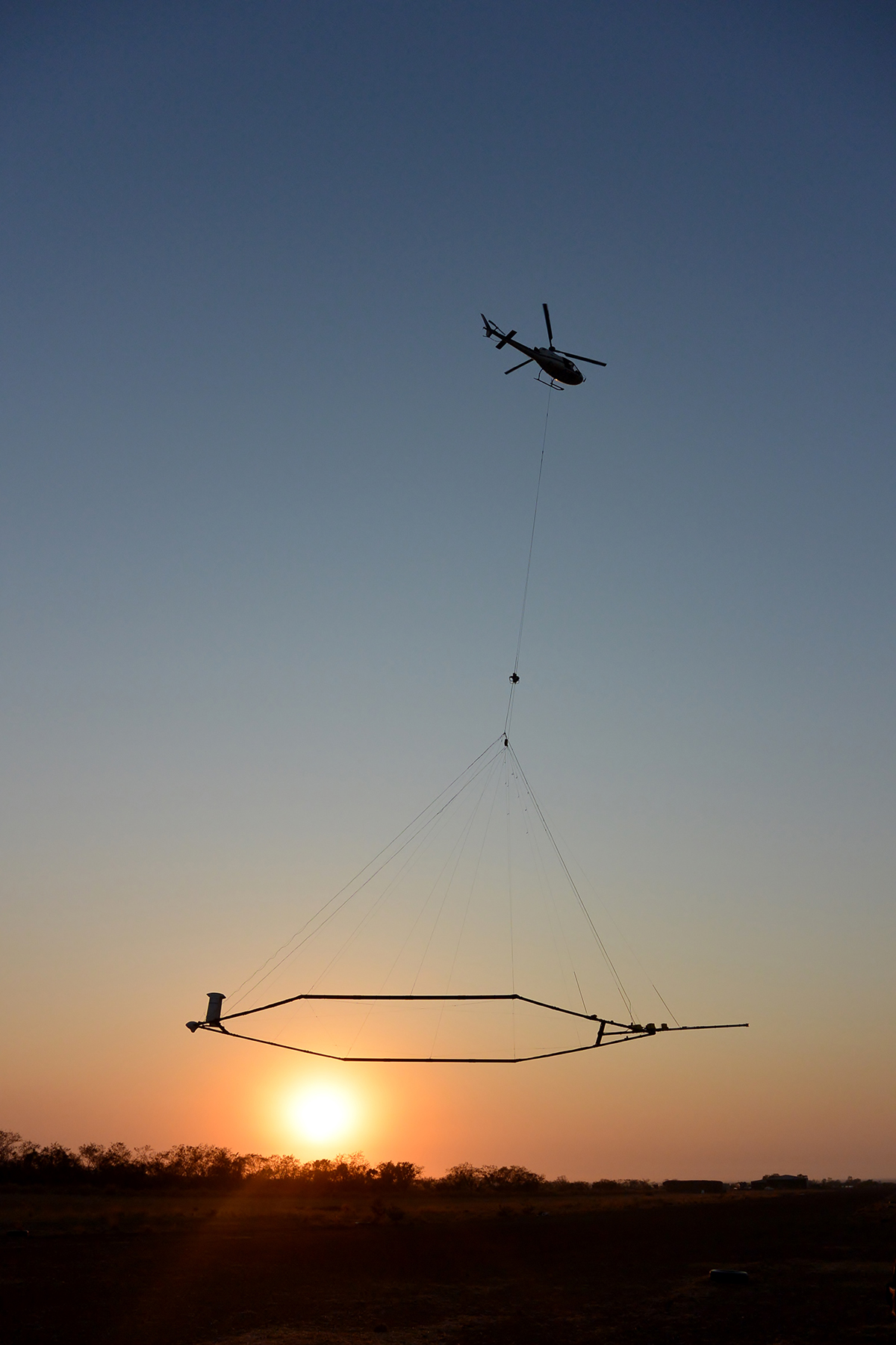
Helicopters are perhaps at their coolest when they’re being used as flying cranes — from a long dangling cable, they can carry everything from cars, to crates, to giant hanging saws.
What you might find altogether more curious are the helicopters that fly around carrying gigantic flat antenna arrays. When you spot one in the field, it’s not exactly intuitive to figure out what they’re doing, but these helicopters are tasked with important geological work!
Looking Down From Above
In the popular imagination, the Earth’s magnetic field is useful for finding north with a compass. In day to day life, that barely comes up, and we don’t give the magnetic field much thought beyond that. However, the reality of Earth’s magnetic field is that it is variable all over the surface of our planet. By measuring it, we can gain great insight into what lies beneath our feet.
Magnetic surveys are an important tool in geology and archaeology. In the latter regard, they were perhaps best popularized by the TV show Time Team. The series would often employ geomagnetic surveys to discover artifacts or structures beneath the ground. The typical technique used on the show involved someone walking around a site with a magnetometer while logging the magnetic field strength as they went. By running the magnetometer in a grid pattern across a site, it was possible to build up a local map of the magnetic field, which could reveal anomalies lurking underground.
That’s all well and good if you wish to survey a small garden or perhaps a single field. If you want to survey a larger area, though, doing a survey on foot isn’t really practical. But you can apply the same techniques in the air at speed, and you can even extend them further, too!
You can do magnetic surveys much faster using a helicopter instead. The basic theory is the same, carrying a magnetic sensor over terrain allows the measurement of the local magnetic field. The difference is that a helicopter can move much faster and thus cover a greater area more quickly, albeit at somewhat reduced resolution. Magnetic field data is great, but there’s so much more that can be gained by exploring the electromagnetic spectrum, too.
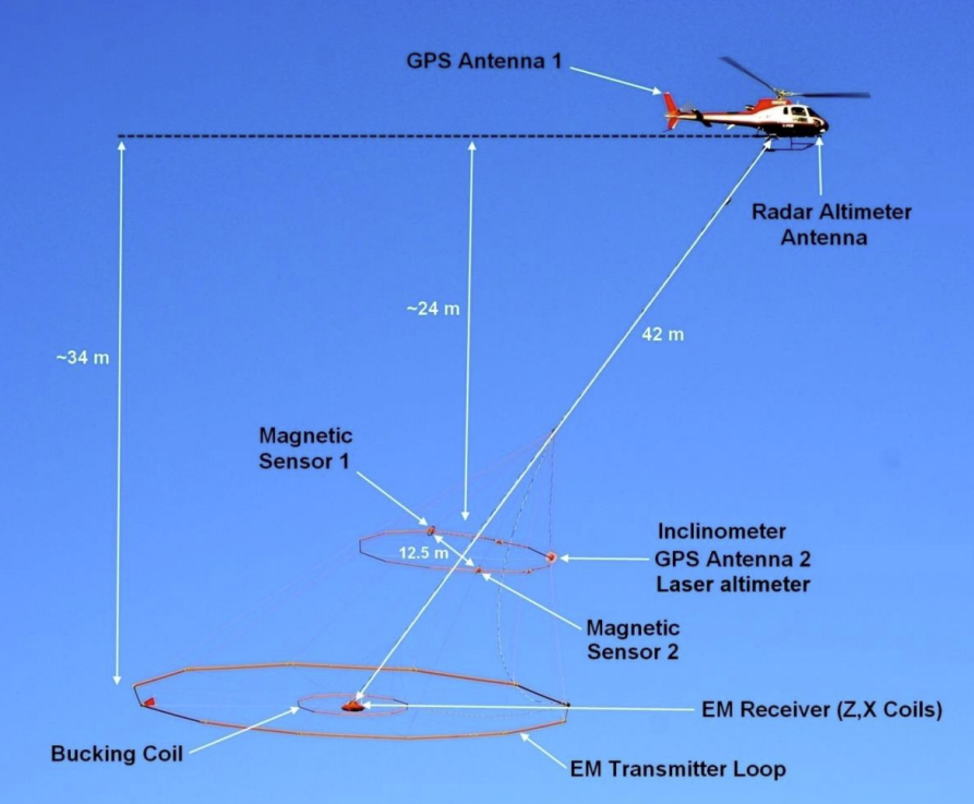
By transmitting radio waves from a giant antenna, it’s possible to excite eddy currents in the ground itself which can then be picked up by a sensitive receiver similarly dangling from the aircraft. A single aerial survey aircraft can carry both magnetic sensors and EM equipment on the same mission to gather both kinds of data at once.
Aerial electromagnetic surveys (AEM), as they are known, aren’t so much used for finding Roman coins or small structures under the ground. Instead, they’re used to better understand the makeup of the ground itself. An aerial survey can reveal electrically conductive materials in the ground, of which there are many.
Graphite, clays, sulfides, or salty groundwater all show up differently on an electromagnetic survey compared to non-conductive minerals or fresh water. These elements can be revealed by an antenna dangling from a helicopter, in combination with other geological data and careful analysis.
Typical AEM missions involve flying at moderate speeds of 70 to 120 km/h along the ground, generally on a path of parallel lines to cover a given area. Altitudes are low, on the order of 100 meters or even less, to keep the antennas close to the ground. Excitation and receiver antennas usually measure tens of meters in diameter. AEM surveys can be remarkably sensitive. It’s possible to pick up variations in the conductivity of the soil up to several hundred meters deep with the right equipment. As you might expect, the local ground composition plays a role in what’s possible, too.
Often, an aerial study is designed to zero in on a particular geological feature or material of interest. Then, the survey area and equipment can be tuned to ideally reveal the expected contrast in conductivity or magnetic field.
Governments and private enterprises using the technique more commonly than you might think. For example, the California Department of Water Resources uses AEM surveys to hunt for underground aquifers. might be using an AEM survey to find an underground aquifer, or a conductive graphite seam deep in the ground. The US Geological Survey uses the technique for all kinds of purposes, and has been doing so since the 1970s. It has looked for subsurface water and underground minerals, amongst other things. There’s an interactive tool for finding survey data, much of which is available to the public.
There is a great deal of mistrust in the wider public these days, with conspiracies around chemtrails, 5G cellular networks, and so many other similar topics. It won’t shock you to know that there are people that freak out when they see a helicopter hauling a gigantic antenna array at low altitude.
For this reason, many government agencies specifically release documents to explain the purpose of AEM surveys, and to highlight that they pose no risk to the public, wildlife, or the natural environment itself. It may seem silly, but AEM survey craft do look a fair bit more sci-fi than most other flying vehicles, so the cautious approach is understandable.
You probably won’t spot an AEM survey craft in the suburbs, but if you’re out in some wide open natural area, you just might. If you’re really keen on seeing one in the flesh, though, you’re best advised to get yourself a geology degree and a job in the field. Then, you might even pick up the skills necessary to specify, execute, and interpret the results of an electromagnetic aerial survey. When you do, be sure to let the world know what you found out!